Clinton – Mintaro Hut (20.6 km), excursion to Mackinnon Pass (8.0 km)
Monday, March 11: Cloudy at first, with a few drops of rain, later mainly sunny with a few clouds
GPS Tour
Youtube Video
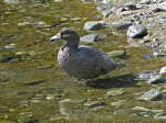
Whio (“blue duck” – Hymenolaimus malacorhynchos) wading in the Clinton River
Was up at 6:00 – surprisingly snore-free night, although the other hut had copped more than its share of snorers – and had breakfast with Alissa (student of landscape architecture) before most people were out and about. Packed up my stuff and was away just after 8:00, after sending an OK with the spot tracker & getting a satellite fix for the GPS. First partner was Franklin (engineer from New York) and then we caught up with Alissa who was visiting all of the ponds. Lots of shots of robins playing around and saw a whio flying at a pool @ 4 miles. After a couple of ponds I had seen enough and powered on, overtaking two German couples (younger & older), and Mark. A couple of shots along the way – Hirere Falls got the first bracket, and then there was also a first panorama of the receding Clinton Valley. Stopped at the Hidden Lake, and just past the next lake there was a whio standing in the river, which I photographed.
Mackinnon shelter with the loo with a view to the right, from the Clinton Valley
From now on the views become more dramatic, and most of the streams – or what is currently left of them – are bridged, a fact that somehow escaped my attention in 2009. A couple of views of the Mackinnon Pass, and then a couple of last views of the valley.
Mark and a day walker who was trying for the Mackinnon Pass and back on the last boat passed me at an impressive pace, and pretty soon afterwards we arrived in Mintaro, to be followed soon after by the younger Germany couple: Andrea (neurologist, Ulm) and Kobinian. Had lunch to the tune of people arriving. We must have gotten in just after 1:00, and by 2:00 we were on our way up the pass for the photography session.
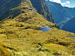
Mackinnon Memorial on the lower pass, Arthur Valley to the right
At the monument I elected for the top of the pass for the first 360°, then a partial pan of the Clinton Valley, followed by several other short pans, and a couple of vertical pans as well. In all about 800 single photographs, most of which will be brackets. Pretty impressive achievement on basically a pair of batteries, but also an achievement in terms of getting the whole shebang together for a reprise of the Milford at all.
I left Franklin and Mark on the pass, leaving at around 5:00; the last shots were a repeat of the infamous five-fold bracket of the partially shadowed upper Clinton Valley face – a bit of cloud diffused the light a little, possibly softening the effect additionally to the bracketing.
| GPS Tour: Milford Track, Day 2, Clinton – Mintaro Hut, Mackinnon Pass |
|---|
Was back down rather rapidly after that, as I had packed what I needed into the sports shoe bag. Started cooking the rice, peas and instant noodles mix at about 6:30.
Had met the warden (with weka) repairing the track on the way up and she had her talk planned for 7:00. Very lively person (Catie) and at the end of her talk asked her about the white-blossoming tree, one of whose blossoms I had brought back down the pass with me – it is the ribbonwood (and this was correct).
ISS failed to show (should have listed the azimuths as well) and most people are fairly subdued. Have a bunk in the same room as last time, and possibly there are no snorers in there. At least, we tried.