Different means of travel, different speeds. This sort of put trip planning off a little. On the other hand, not having to spend a whole day slogging on towards some distant goal had its benefits, not least of which was enjoying the scenery. More could have, should have been done, but I’ll happily leave that for another time.
| Section (with links) | Distance | Track Time | Break | Mean speed | Median time|distance |
| Picton – Mistletoe Bay | 19.4 km | 3:26 h | 2:14 h | 5.65 km/h | 6.53|6.76 km/h |
| Mistletoe Bay – Kumutoto Bay | 19.9 km | 3:44 h | 2:54 h | 5.35 km/h | 5.74|6.18 km/h |
| Kumutoto Bay – Blumine Island | 21.9 km | 3:42 h | 1:34 h | 5.94 km/h | 6.60|6.73 km/h |
| Blumine Island – Cannibal Cove | 16.3 km | 2:46 h | 1:21 h | 5.92 km/h | 6.55|6.68 km/h |
| Cannibal Cove – Ship Cove | 7.8 km | 1:34 h | 0:54 h | 4.99 km/h | 6.04|6.29 km/h |
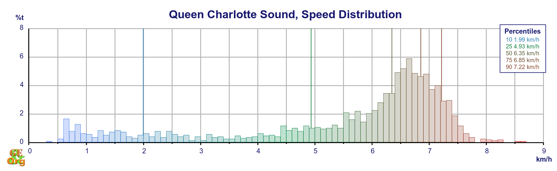
| Totals | 85.5 km | 15:20 h | 8:49 h | 5.57 km/h | 6.35|6.57 km/h |
| Summary of paddling the Queen Charlotte Track | |||||
The boat was no doubt fast (and special thanks again to Marlborough Sounds Adventures for a very reasonably priced 5-day hire and return transport – $240 per person), possibly due to the fact that it was not packed to the hilt. A later trip in western Sweden using plastic boats and carrying all supplies for twelve days proved to be somewhat slower.
As for the remainder of the finances – easily done. The four camping sites cost a total of $34 per person, and the supplies came to $50 for the two of us, $25 a piece. In my view that totals just under $300, which is pretty decent.
Slide Show
The 2018 Sweden trip (circumnavigation of Orust and Tjörn, starting and finishing in Göteborg) not only required taking all supplies (including water for at least three days at a time) but also involved transporting major cooking equipment (5 kg gas bottle! dual-flame cooker!). If anything the sea in Queen Charlotte Sound was also somewhat more tranquil than off the Swedish coast, although for a longer stretch in Sweden we were within a couple of sounds. But the longer stretches over the open sea which did involve ploughing through waves may have made the trip slower. It was only really in the run up to landing at Kumutoto, and later en route to Cannibal Cove that we experienced rougher seas, although even they were not really enough to affect average speeds.
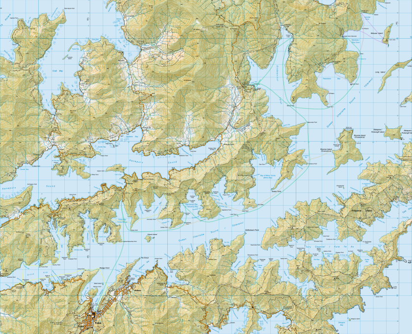
Topo Map with GPS
Of course, the weather could have become much worse on either trip. However, in the case of Queen Charlotte, there were still plenty of sheltered bays that went unexplored, plenty of campsites that we simply passed by. There is something to be said for not overdoing the distance on this trip – plenty of time to put the tents up to dry, a bit of time for photography and exploration, and fewer blisters. The campsites were simple, but they all had water (which should be boiled) and toilets, even tables and benches. What more could you ask?
If anything, I would be a bit more adventurous – why not try Nelson to Picton all the way next time? Or just spend an extra day in Endeavour Inlet? In either case an unforgettable way of seeing New Zealand.