Category Archives: GPS Tracks

Epilogue: Maps…

On topographical and geodetic maps, and PHP and JavaScript scripts for converting between the two

First day of the Milford Track
First day of the Milford Track. Buy the Milford Track Great Walk Topo Set (2013) – €5

I’ve occasionally said in jest that the earth is flat, at least for the purposes of drawing small scaled maps, such as those that appear in the pages of this blog.

But what I’ve somehow missed up until now is that there are two types of flatness.

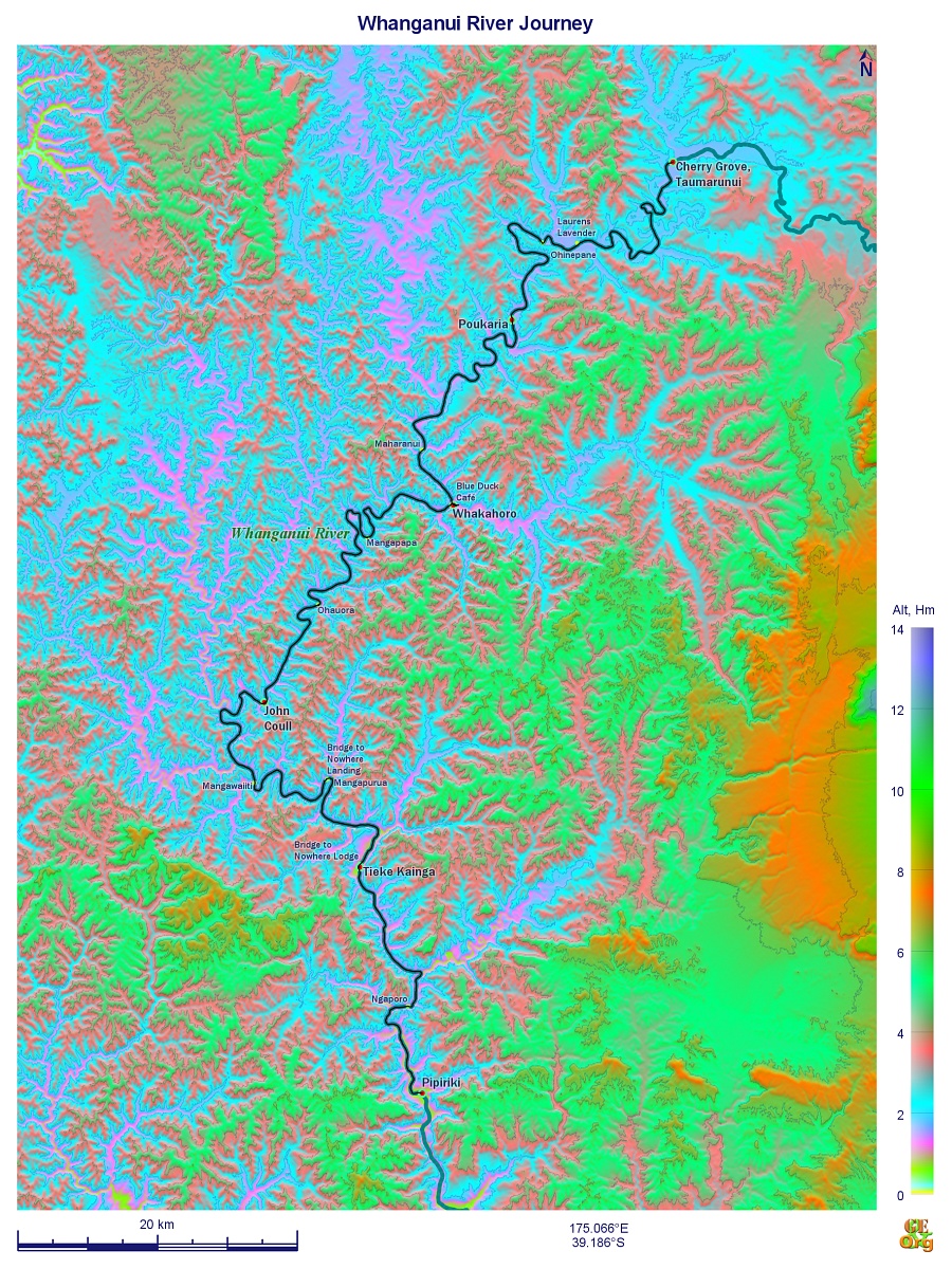
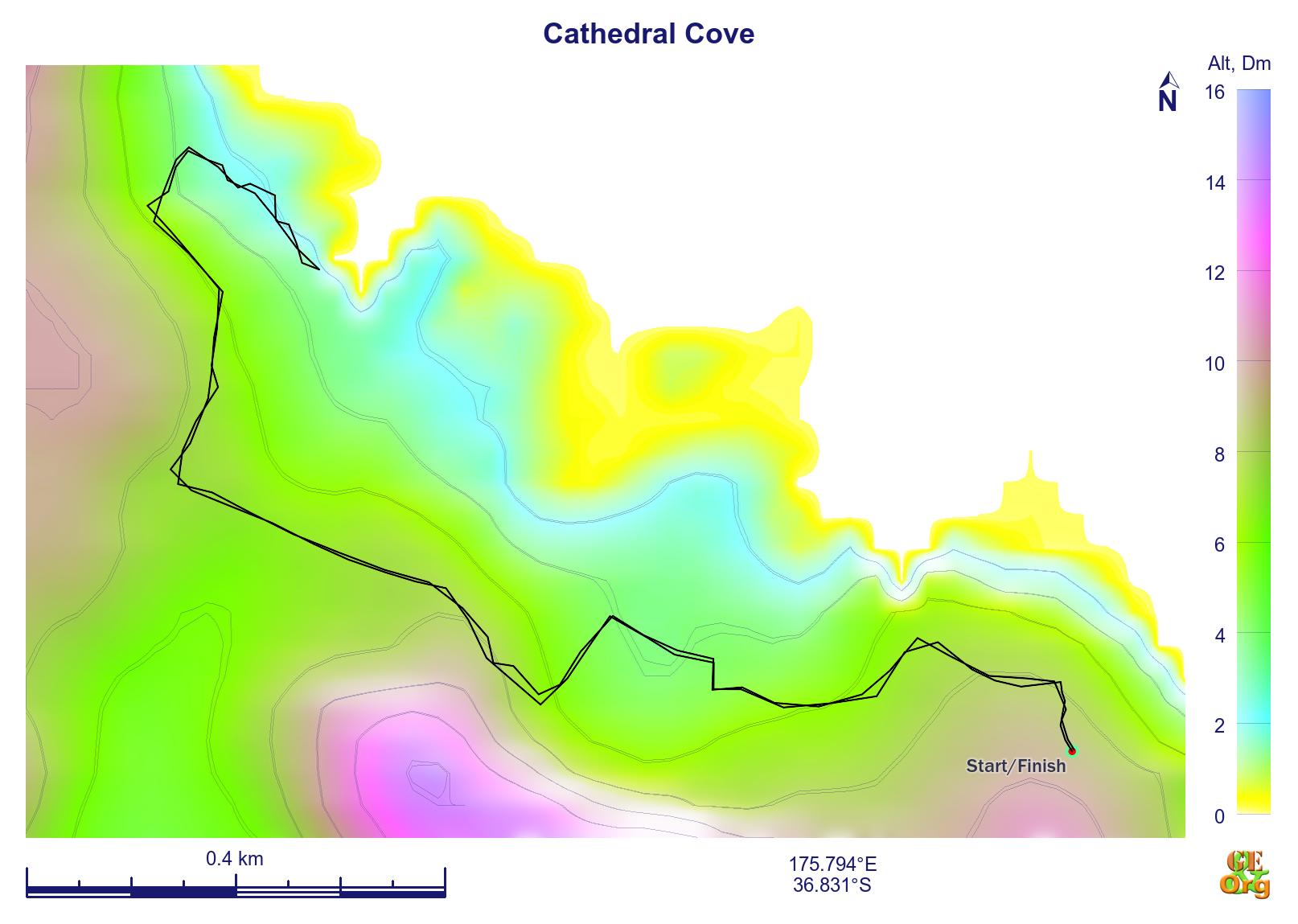
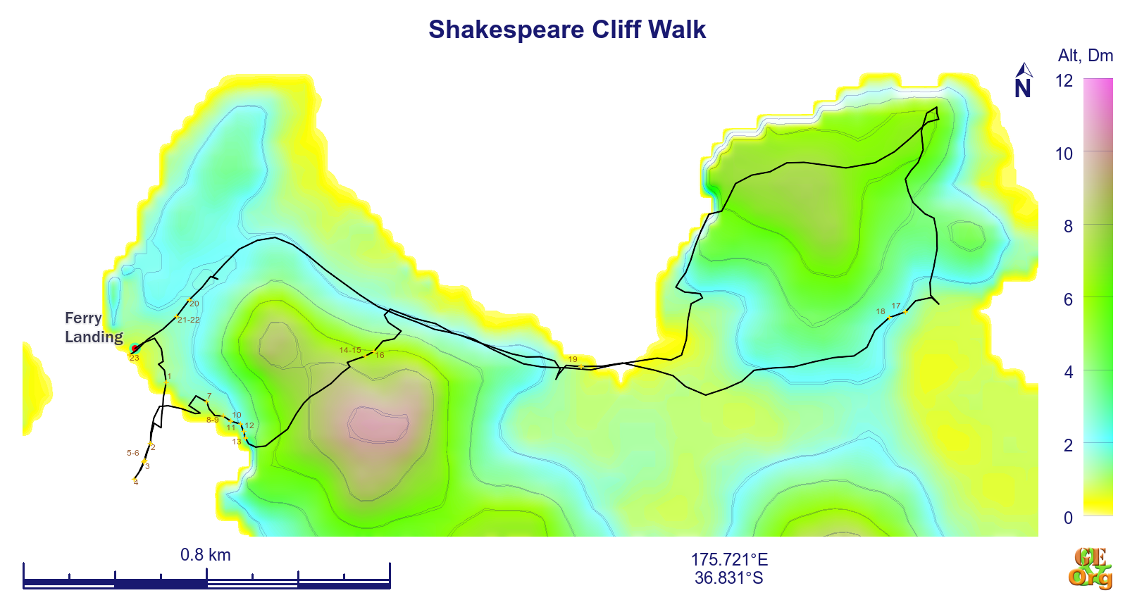
For everyone with a GPS machine, let’s see what you have got and what you are missing. Your machine will produce degrees east or west of the meridian and north or south of the equator. That’s called geodetic data, and it’s fine. That’s what the elevation data produced by the SRTM (Shuttle Radar Topography Mission) are mapped out as, it’s the data that GEOrgET works with.

But it’s not the data that mapmakers express themselves in. They deal in things called Transverse Mercator projections, and they function a little differently from taking one “square degree” and squishing it into approximately its physical dimensions. Starting from a reference longitude (the north-south line), they branch off at various latitudes, initially directly to the east or west and map out a rectangular grid. Can you see what is going to be off kilter here? The further south you go, the more the line you are following, the tangent (to the east or west) will deviate southwards from the arc of the latitude. In the same way true north starts to deviate (in the Southern Hemisphere) to the east or west corresponding to how far east or west of the reference longitude you are. Read more…

Epilogue: Introducing GEOrgET 1.0

Georget_large
GEOrgET 1.0, new 3D logo

By now the maps and charts derived from the GPS tracks that I’ve recorded have become part and parcel of the blog. The software responsible for this is GEOrgET (GoogleEarth Organiser, Editor & Toolkit). However, with the gradual publication of 1 arc second elevation data, it was time to have another look at the program to see if the greater resolution was worth accommodating.

Three areas needed reviewing: The first was cosmetic – the logos and how the program looked and felt; the second was introducing the 1 arc second data and adapting the program accordingly; and the third was the under-the-hood question of the coding.

The cosmetic improvements included the new 3D logos which were fun to design and implement. Then the program handling had to be addressed. Directory and file selection are now achieved with a single click which automatically reloads the page; and to avoid clutter the latest version of multi-version files is only ever shown, and non-editable files are never shown. Read more…

Epilogue: Debriefing the Great Walks – Whanganui River Journey

Index

I’ve dealt with the kayak operators in the previous blog, now’s the time to look at my (our) side of things.

Travel Planning

Whanganui River Journey
Buy Whanganui River Journey GPS track here for €5
Although the general suggestion is to do either Taumarunui to Pipiriki (150 km) in five days or start further down the river at Whakahoro and do the trip in three days, these are very condensed trips with little room for error. I think the worst mistake made was to schedule the first overnight stop in Poukaria.

The big problem here is that leaving Cherry Grove just after 11:00 for a 36 km leg is just too much for one day. The kayaking alone takes a good five hours, so only two rather restricted stops could be scheduled in order to get to Poukaria by dusk. Also, this is the roughest part of the whole trip, with at least two major rapids, the result of which is that everything is wet, and Poukaria Campsite lies so close to the river that overnight drying of kit is impossible.

A much better strategy would have been to schedule the stopover in Ohinepane (22 km), after taking at least one full lunch break beforehand, and an afternoon stop at Laurens Lavender (1381 River Rd, Aukopae 3991, laurenslavender.com, signposted on the river) for a cuppa and a slice of cake. This would mean a mid afternoon arrival at the campsite, after which everything could be dried, the dry bags repacked, etc. The following day Whakahoro could be reached after 35 km – again about five hours of paddling – but this time with a departure at around 9:00 (or even earlier) and two breaks along the way and arrival at the campsite by around 4:00 which seems realistic. Here again I would make better use of the Blue Duck Café (blueduckstation.co.nz, evening meals by prior arrangement) here to get some fresh food to eat, and of the location of the campsite and hut on higher ground just outside of the valley proper to allow the gear to dry. Read more…

50. Paihia – Rawhiti (Cape Brett Walkway)

Wednesday, April 1: Sunny with a few clouds on the horizon; quite warm

Tramping: Rawhiti – Cape Brett via Deep Water Cove, 16.3 km

Cape Brett Hut (DOC, $15, gas cookers, no heating; $30 track fee for private land)

Managed to struggle up at a quarter past seven and fry two eggs for breakfast, pack everything up into the backpack for the hike and then everything else into their bags and into the car and was ready to go by 8:30.

Cape Brett View to Go
Cape Brett View to Go, snapshot
Short drive to the ferry and was soon on the other side (car $11) and down the meandering road to Rawhiti. I had been considering walking via Whangamumu and that track entrance was 5.4 km down the road (a gravel road for the most part at that) but as we will see that wouldn’t have been such a good idea.

Found someone’s front yard to park the car in ($5) and swapped shoes for the hiking boots and was ready to tramp by 9:45. Views of the bay begged to be photographed but the batteries packed in immediately and once on the track the next bay beckoned likewise so I got out a box of batteries and kept them in an outside pocket just in case. Read more…

49. Paihia

Tuesday, March 31: Sunny with a few clouds and a bit of a breeze on the bay

Kayaking: Paihia – Bay of Islands – Waitangi, 5.7 km

Centabay

In the night the keys had slipped off the towel rail and dropped onto the floor among the stuff packed there and it took a little while of thinking to work out where they had to be. Was awoken by the manager to get me to move the car and I moved it onto the street where a 120 minute slot was free. About the only business that had to be transacted was printing out the DOC ticket for the walk tomorrow and since the library had banished all wifi users to the park I tried a commercial operator in an “adult” shop. First computer had something wrong with the graphics card, but the second printed out the pdf just fine for $1.6. A couple of things had to be bought for the hike and I thought that – just for the two days – I would opt for bread and have sandwiches made up for both days’ lunches. Short inquiry at the i-site about safe parking – apparently possible at either a camping ground or the backpackers. Read more…

47. Papakura – Auckland – Ruawai

Sunday, March 29: Rain at first clearing to cloudy through to sunny with a shower or two

Tramping: Tokatoka, 0.6 km (return)

Peter & Sara’s (airbnb, $50)

It was pouring when I got up, and I had my breakfast and was finished well before Michelle got up. I was in no hurry and it was raining so I leisurely packed my stuff. In time she was up and under the shower; then I gave her a copy of the book and was off to Tom’s.

Bella
Bella watching the sheep from Tokatoka
Was there pretty much on the dot of 11:00 and Cather & the boys were still collecting their stuff for the day’s programme. Charlotte was very enthusiastic and had to be taken outside. Eventually all were ready to leave and Tom & I went down to Takapuna to a very posh place with all-organic, gluten-free etc. stuff for brunch. Tom had some scrambled eggs and I opted for the chilli chicken on ciabatta, both with flat whites. Read more…

44. Whitianga: Cathedral Cove

Thursday, March 26: Some fine spells in the course of the day but mainly cloudy, and rain in the evening

Tramping: Cathedral Cove, 3.3 km

On the Beach

Cathedral Cove Archway
Archway at Cathedral Cove at high tide. Median pixel of ca. 540 shots

The two Chinese girls were very well organised and after their instant noodles for breakfast and some chocolate they had packed up what little they had and were downstairs on the dot of 10:00 to wait for their bus, which as far as I could see was some time in coming. In the meantime I had gone for a walk in the direction of the outer settlements and had not seen very much, except for one heron who allowed me to get very close.

Tourist trap extraordinaire
Tourist trap extraordinaire. [download id="1966"]
I decided on driving out to Hahei to see what the story with kayaking was, although the waves today looked no smaller that yesterday’s – because the brochure said, “Daily.” Had a quick lunch of some toasted cheese and tomato sandwiches and then took off down the road (~30 km) with most of the equipment I thought was needed. Found the place in Hahei, but no one at home; only a handwritten sign that the morning had been called off but that the afternoon was running. Found some phones at the tiny shopping centre and called but the afternoon tour had also been called off; was advised to call back tomorrow morning. Read more…

43. Whitianga

Wednesday, March 25: Sunny and warm, one big dark cloud in the afternoon, but no rain

Tramping: Shakespeare Cliff Walkway/Ferry Landing, 5.7 km

On the Beach

Comfortable stroll
Comfortable stroll. [download id="1960"]

Everything was very laid back and late this morning. I extended for another two days and asked about the kayaking, but the waves were too high today, so I grabbed a body board instead. The waves were indeed high and crashing very close to the beach, although there didn’t seem to be an outgoing current. One or two places much further down the beach seemed to have better breaking properties, and I was only trying out the waters for a bit. Came back, showered the sand off, went for a stroll around town, withdrew some cash and bought a couple of tomatoes for the cheese sandwiches I was having for lunch. Managed to get them toasted (or rather, fried) and that was fine. Read more…

41. Tauranga: Mt Maunganui

Monday, March 23: Cloudy with rain all the morning, becoming very much finer & warmer by the late afternoon

Tramping: Mt Maunganui, 6.3 km

Liz & Phil’s

The dogs (Airedale terriers) hadn’t woken me @ 5:00, but from about 7:45 onwards I was awake. Breakfast (and Liz insisted that there would have to be one, otherwise her business wouldn’t be a B&B) was cornflakes, coffee from a very expensive looking machine and at least tasted like something, toast, cantaloupe and some spreads which I didn’t have.

Perfect day for a technical day, and I started off by trying to synchronise the internal and external hard drives in terms of pictures. For D: to have the absolute essentials that would be the main folder with the processed images (all DNG & IMG – debarrelled and dechromaticised) and one subfolder with thumbnails. It has occurred to me during the day that PPP could work primarily with G: as the source and copy some files to the internal hard drive at the end of the day. If that were the case, then it would also be worth considering extending the postprocessing procedure beyond just ATM (advanced tone mapping). Read more…

39. Waipawa – Cape Kidnappers – Taupo

Saturday, March 21: Sunny the whole day with very few clouds, warm

Tramping: Clifton to Cape Kidnappers along the beach and back, 19.1 km

Stag Park Diner, 151 Napier Taupo Highway, State Highway 5, Taupo 3379, tel.: +64 7 378 6403, twin as single, shared facilities ($55)

Layers leaching
Leaching lime is most commonly seen, but also iron oxide, forming strange patterns

It was nice to have slept in a real bed again, above all, with a real pillow. The room was spotless and the fridge with freezer rebooted the chilly bag; a short trip to the supermarket procured everything that was needed for breakfast and lunch, and I was away back on the road to Hastings by 9:30.

In Hastings the library opened as I arrived and they were charging for the wifi @ $2.5 per half hour. Tried the BBH places in Taupo, but all booked out, then for the 0800 number for the Taupo i-site to call when I came back from the walk in the afternoon. Read more…