Category Archives: Topo Map

Debriefing the Other Tramps

Tongariro Northern Circuit

tnc
Buy Tongariro Northern Circuit Great Walk Topo Set – €3

Admittedly: The walk can be done in two days. But…

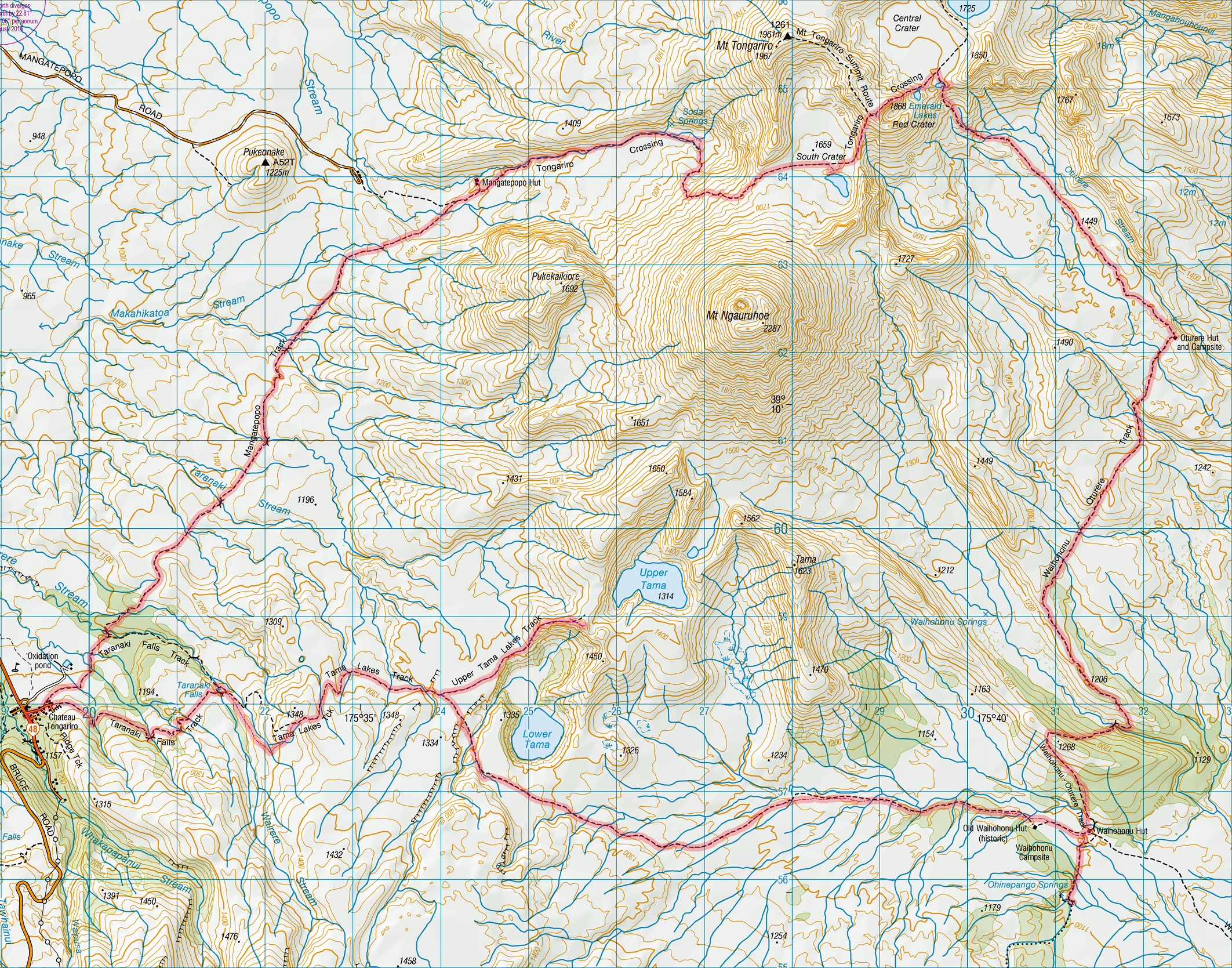
That would be turning into a raceway. If the weather is good, then the excursions to the Taranaki Falls and the Tama Lakes are indispensable. Since most of the track is very open, views from anywhere can be pretty spectacular, but these two sights should not be missed.

The Crossing itself passes between the two mountain peaks of Tongariro and Ngauruhoe and the question remains whether to climb these peaks. If the day’s section is only from Mangatepopo to Oturere or vice versa, then there would be time to attempt one peak. Ngauruhoe being much higher (2291 m) is more tempting than Tongariro (1978 m). However the surface of Ngauruhoe is loose scree and there is a real danger of snow falling at any time of the year, so that Tongariro is the better bet.

The condition of the “Hole” (Mangatepopo – Whakapapa) should be considered carefully. Recent rain will make this section almost impassable and in this case it is advisable to start or finish the track at the Mangatepopo carpark. Just make sure to arrange transport before starting the track. The bus that drops off the day hikers for the Crossing leaves at around 8:30. Read more…

Epilogue: Maps…

On topographical and geodetic maps, and PHP and JavaScript scripts for converting between the two

First day of the Milford Track
First day of the Milford Track. Buy the Milford Track Great Walk Topo Set (2013) – €5

I’ve occasionally said in jest that the earth is flat, at least for the purposes of drawing small scaled maps, such as those that appear in the pages of this blog.

But what I’ve somehow missed up until now is that there are two types of flatness.

For everyone with a GPS machine, let’s see what you have got and what you are missing. Your machine will produce degrees east or west of the meridian and north or south of the equator. That’s called geodetic data, and it’s fine. That’s what the elevation data produced by the SRTM (Shuttle Radar Topography Mission) are mapped out as, it’s the data that GEOrgET works with.

But it’s not the data that mapmakers express themselves in. They deal in things called Transverse Mercator projections, and they function a little differently from taking one “square degree” and squishing it into approximately its physical dimensions. Starting from a reference longitude (the north-south line), they branch off at various latitudes, initially directly to the east or west and map out a rectangular grid. Can you see what is going to be off kilter here? The further south you go, the more the line you are following, the tangent (to the east or west) will deviate southwards from the arc of the latitude. In the same way true north starts to deviate (in the Southern Hemisphere) to the east or west corresponding to how far east or west of the reference longitude you are. Read more…

Epilogue: Debriefing the Great Walks – Whanganui River Journey

Index

I’ve dealt with the kayak operators in the previous blog, now’s the time to look at my (our) side of things.

Travel Planning

Whanganui River Journey
Buy Whanganui River Journey GPS track here for €5
Although the general suggestion is to do either Taumarunui to Pipiriki (150 km) in five days or start further down the river at Whakahoro and do the trip in three days, these are very condensed trips with little room for error. I think the worst mistake made was to schedule the first overnight stop in Poukaria.

The big problem here is that leaving Cherry Grove just after 11:00 for a 36 km leg is just too much for one day. The kayaking alone takes a good five hours, so only two rather restricted stops could be scheduled in order to get to Poukaria by dusk. Also, this is the roughest part of the whole trip, with at least two major rapids, the result of which is that everything is wet, and Poukaria Campsite lies so close to the river that overnight drying of kit is impossible.

A much better strategy would have been to schedule the stopover in Ohinepane (22 km), after taking at least one full lunch break beforehand, and an afternoon stop at Laurens Lavender (1381 River Rd, Aukopae 3991, laurenslavender.com, signposted on the river) for a cuppa and a slice of cake. This would mean a mid afternoon arrival at the campsite, after which everything could be dried, the dry bags repacked, etc. The following day Whakahoro could be reached after 35 km – again about five hours of paddling – but this time with a departure at around 9:00 (or even earlier) and two breaks along the way and arrival at the campsite by around 4:00 which seems realistic. Here again I would make better use of the Blue Duck Café (blueduckstation.co.nz, evening meals by prior arrangement) here to get some fresh food to eat, and of the location of the campsite and hut on higher ground just outside of the valley proper to allow the gear to dry. Read more…

51. Rawhiti – Russell (Cape Brett Walkway)

Thursday, April 2: Some cloud came over during the course of the night and there was rain in the early morning, clearing to a fine & sunny day

Tramping: Cape Brett – Rawhiti, 15.1 km

Wainui Lodge, 92D Te Wahapu Rd, Russell 0272, tel.: +64 9 403 8278, double as single, only two rooms, max. 5 guests (BBH, $50 + 3)

Cape Brett Cliffs
Cape Brett Cliffs, snapshot

I had photographed three fixed time sequences during the night: One of the rising moon, one of the moon @ full zoom (A470), and one of the Southern Cross (SX120) until the batteries gave out. The camera was retrieved due to increasing cloud, but the tripod had been tied to the picnic table with a new twist-and-tighten mechanism which I was unwilling to untie late at night.

The hut was still very warm, but there were no bugs so I slept on an open sleeping bag. It started getting light about 6:30 and by 7:15 the sun was rising. Now this would have been a good sunrise to shoot, but I was concentrating on getting out alive. Breakfast was quickly dealt with, the salt shaker seemed to work fine and everything was washed, dried (including the sox) and packed away by 8:30. Swept out the hut (a little bit of grass cuttings had found its way into the hut) and then I was ready to go. Read more…

32. Whakatane: Nga Tapuwae o Toi

Saturday, March 14: Sunny and very warm, clouds appearing in the evening, and some rain

Tramping: Nga Tapuwae o Toi, 16.9 km

Windsor Lodge

The weather was very tempting for a paddle so I was up and organised early, and Kenny the kayak man offered a freedom hire, the only problem was that it was from his place. I indicated that I would take it, and set off with a Google Map in mind to drive the 30 or so km down to his place. Was ready to leave here just after 9:00. Read more…

30. Rotorua: Lake Tarawera

Thursday, March 12: Rain at first, then somewhat drier, rain again in the evening

Tramping: Tarawera Trail, 13.4 km

Astray (BBH, $37 + $3)

The day wasn’t turning out so well for a tramp, but I decided on going ahead with it anyway. By about 9:30 the car was packed and ready to go, and I was a the car park for the trail by about 10:00. The forecast had been for showers but it was coming down in a constant stream.

I had my full-length trousers and the raincoat on right from the beginning. The path is rather narrow and the wet plants on either side were hanging over the track and transferring water first to the pants and then to the sox and boots. I made brief stops every now and then and at the second picnic place it had virtually stopped raining so I stopped for my two rounds of sandwiches and mandarine for lunch. Read more…

29. Rotorua: Waimangu

Wednesday, March 11: Sunny becoming cloudier in the afternoon, warm

Tramping: 5.4 km

Astray

This place is fairly quiet at night after 10:00, but it was the buses and general traffic that woke me before 9:00. Today’s plan was to do the Waimangu ($36) walk with plenty of time lapses and polarised brackets, and to have it fill up the day.

I was at the car park at around 10:30, and had everything ready except for the hat that I had left in the car. Since Waimangu – as opposed to most of the other thermal/volcanic walks – is very shaded that won’t have made too much difference since sunscreen had already been applied. Read more…

28. Rotorua: Waiotapu

Tuesday, March 10: Sunny with a couple of clouds in the distance, and warm

Tramping: 3.3 km

Astray

Two French girls who are working here have a shared room on our “corridor” and were up very early, which of course had to be followed by everyone else. My first self-provided breakfast was sultana bran, coffee with fresh milk, and toast. Internet was briefly checked for today’s distance, and the clothes that I eventually washed yesterday were still not dry, so I left them on the clothes horse outside reception.

Then it was off to Waiotapu ($32.5) for the photography session. Managed to forget to load the cameras with their usual cards, but had all the spare cards with me and the first one worked for Mel. After buying a ticket I returned to my car where a hitchhiker asked me whether I could ferry him to the geyser, which I did (Tilman from near Stuttgart). We were quite early so I was able to try out various different locations before choosing the very back and getting a couple of sequences of the dormant geyser in the process. Read more…

27. Hamilton – Rotorua

Monday, March 9: A few drizzle patches in the morning & a little cloudy throughout the day

Tramping: 7.5 km

Astray Motel & Backpackers, 1202 Pukuatua St, Rotorua 3010, tel.: +64 7 348 1200, single room scarcely larger than the bed (BBH, $32 + $3 + $5)

Waikato River, Hamilton in the morning

Sleep was so interrupted during the night that I was one of the first at the free breakfast: Cornflakes & milk, coffee, toast, I was ready to leave by just after 8:30. Looking at the maps last night it occurred to me that I might do a river walk to avoid arriving in Rotorua too early, and drove around the corner to the end of the street, parked the car and proceeded to walk towards the town centre and then do a loop of the river involving two bridges before heading back to the car. One bracket of a park with a river landing, quite a pleasant surprise in the middle of Hamilton.

Down by the river
Down by the river, [download id="1793"]
Then it was to a supermarket to buy some strepsils, as I had a rather sore throat after my hattrick of skeptics in pubs, before pushing off down the road to Rotorua with only one further stop to clear the windscreen. Read more…

23. Waitarere – Waikanae Beach: Otaki Forks/Arcus Loop

Thursday, March 5: A couple of clouds about, more in the mountains, but sunny by the sea

Tramping: 3.5 km

James & Julie’s (airbnb, $47)

The only problem with sleeping in the tent – especially so close to the sea – was the dew fall. The whole tent was soaking wet inside and out by morning, and I had pitched it in the shadow of the amenities block from the point of view of the morning sun.

After possibly the last breakfast of tramping/kayaking diet I set about drying things out. In the end I chose the clothes line that runs on the road side of the camp, and within half an hour or so the tent (both internal and external) was dry. The stuff I had washed two days ago was still having difficulty drying but in the course of time was dry enough. Read more…