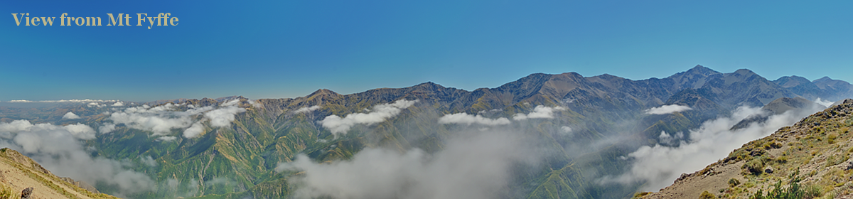
With just over 71 km, the Heaphy Track is the longest of the pedestrian Great Walks, and I use the word “pedestrian” advisedly, because the Whanganui River Journey, a Great Walk that can only be done by kayak/canoe, is twice as long, and the Heaphy is open for pedestrians only in the Great Walks Season (November – April). In the winter time it is a mountain bike track, so be warned.
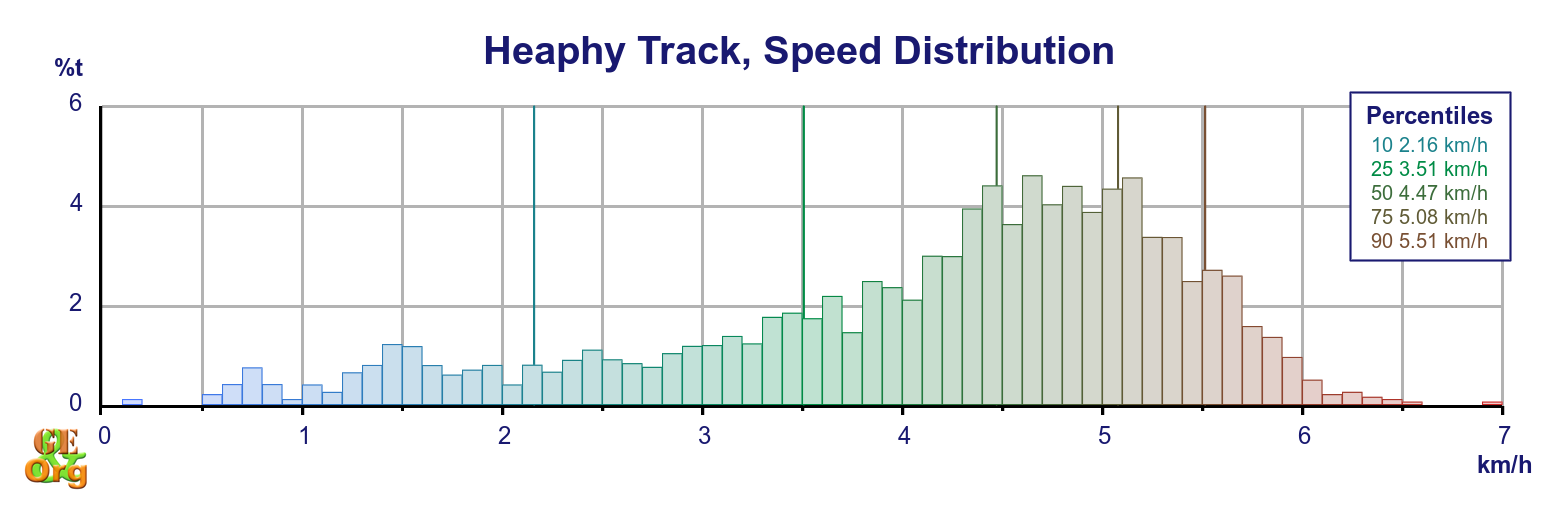
| Section (with links) | Distance | Track Time | Break | Mean speed | Median time|distance | Ascent | Descent |
| Brown Hut Access – Perry Saddle | 16.0 km | 4:09 h | 0:25 h | 3.87 km/h | 4.14|4.39 km/h | 1408 m (D-) | 670 m (M+) |
| Perry Saddle – James Mackay | 21.3 km | 5:04 h | 1:49 h | 4.21 km/h | 4.47|4.67 km/h | 609 m (M-) | 778 m (E+) |
| James Mackay – Heaphy Hut | 18.2 km | 4:17 h | 1:12 h | 4.25 km/h | 4.64|4.88 km/h | 341 m (E+) | 1033 m (M) |
| Heaphy Hut – Kohaihai Carpark | 15.6 km | 3:35 h | 0:23 h | 4.36 km/h | 4.79|5.09 km/h | 504 m (E+) | 508 m (M-) |
| Totals | 71.1 km | 17:05 h | 3:49 h | 4.17 km/h | 4.47|4.72 km/h | 2892 m (M) | 3020 m (M-) |
| Summary of the Heaphy Track. Climb categories are: Flat (< 1.9°/3.3%), Easy (> 1.9°/3.3%), Moderate (> 3.8°/6.6%), Demanding (> 7.5°/13%, < 15°/27%) | |||||||
The track is punctuated by four large, modern huts with all mod cons (as far as Doc huts go) – Perry Saddle, Saxon, James Mackay, and Heaphy – and two smaller, older huts – Gouland Downs and Lewis, in addition to campsites/shelters along the way. This allows for some variation in the itinerary, although the track is eminently walkalble in four days. One variation worth considering is climbing up Mt Perry (1238 m) itself after staying the night at Perry Saddle – a bit of a bushbash, I know, but packs can be left at the hut for the adventure, and if the weather is good then views should be reasonable. Further exploration off the track can be undertaken just past Gouland Downs Hut, where there are limestone caves hidden in a forested outcrop just past the hut. Depending on how much time is spent on these activities, the next overnight stay could be back to Gouland Downs, or onto the next major hut, Saxon. In either case it would be advisable to use Lewis Hut as the next stop, as the Heaphy Hut is just beyond reach.

In fact, if you can’t make the whole distance and were looking for a one- or two-day walk, then starting at Kohaihai carpark is your best bet. One full day of walking will get you to Lewis (@24 km quite a trek, but not much in the way of climbing), and then you can return the next day, and one half-day will get you up to Katipo Shelter (11.5 km), with the afternoon sun shining full on the palms on your return.
There is a high tide warning for this track, one which I don’t quite understand. The surf along some of the beaches is extremely dangerous (make no doubt about it, just a week before I passed through someone was taken out by a wave, never to be seen again). For most people, just being knocked off your feet by a wave will be enough to seal your fate (especially if you are near one of the treacherously calm appearing troughs, where the water drains from the beach out to sea). The bit I don’t understand is that the track doesn’t really come anywhere near the ordinary high water mark (although if a west wind was blowing, the tide might reach further inland). I finished the track within an hour of an approaching high tide without encountering any difficulties. However, make sure you know when the tides are, and if in doubt, stick to a low tide.
Slide Show
Click here to reload slide show
As I’ve mentioned, there are four very modern huts along the track, but to Doc’s disgrace the mattresses in all four huts had had the shit beaten out of them. There’s no excuse for this sort of thing – the mattresses in the huts on the Dusky Track were in better condition than they were here, and Doc is charging $32 a night on this track. The proceeds from a single night should have been sufficient to replace the mattresses.
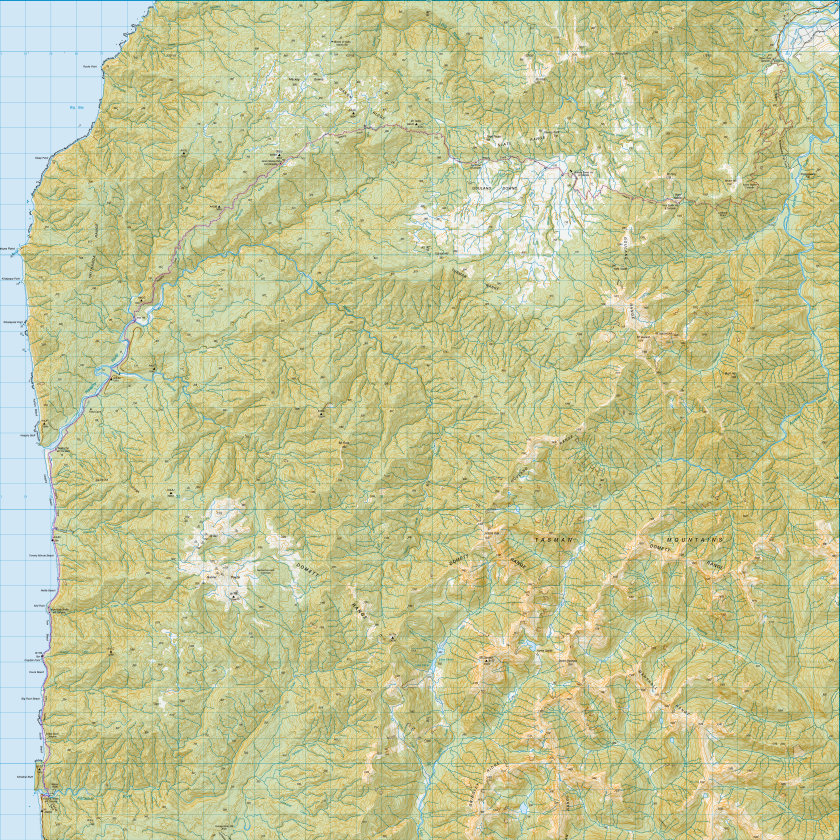
Topo Map with GPS Tracks
Other points to note:
The Heaphy Shuttle Bus provided good service for $65 – but note that exact change is required when paying the driver by cash, and that credit card payments are only available on the net, or through booking agencies such as the i-site.
Track deviations. There are minor deviations just before Perry Saddle Hut, on the descent from James Mackay, and most importantly, the bridge over the Gunner River is to the west of its marked position, all of which reflect new track positions. The walk along Scotts Beach was a deliberate deviation on my part.