This was one of the more enjoyable options of returning from the Heaphy Track, by as direct a means as possible, and as such is one of the classical combination routes. With accommodation and the supermarket in Karamea, this was also an ideal way of doing a much longer hike than would otherwise be possible.
| Section (with links) | Distance | Track Time | Break | Mean speed | Median time|distance | Ascent | Descent |
| Little Wanganui Road End – Taipo | 20.3 km | 6:56 h | 0:47 h | 2.93 km/h | 2.74|3.66 km/h | 1475 m (M+) | 835 m (M+) |
| Taipo – Stone | 18.6 km | 6:09 h | 0:40 h | 3.03 km/h | 3.12|3.52 km/h | 889 m (M) | 911 m (M) |
| Stone – Price’s Clearing | 19.7 km | 4:56 h | 0:40 h | 4.00 km/h | 4.21|4.51 km/h | 646 m (M-) | 1033 m (M) |
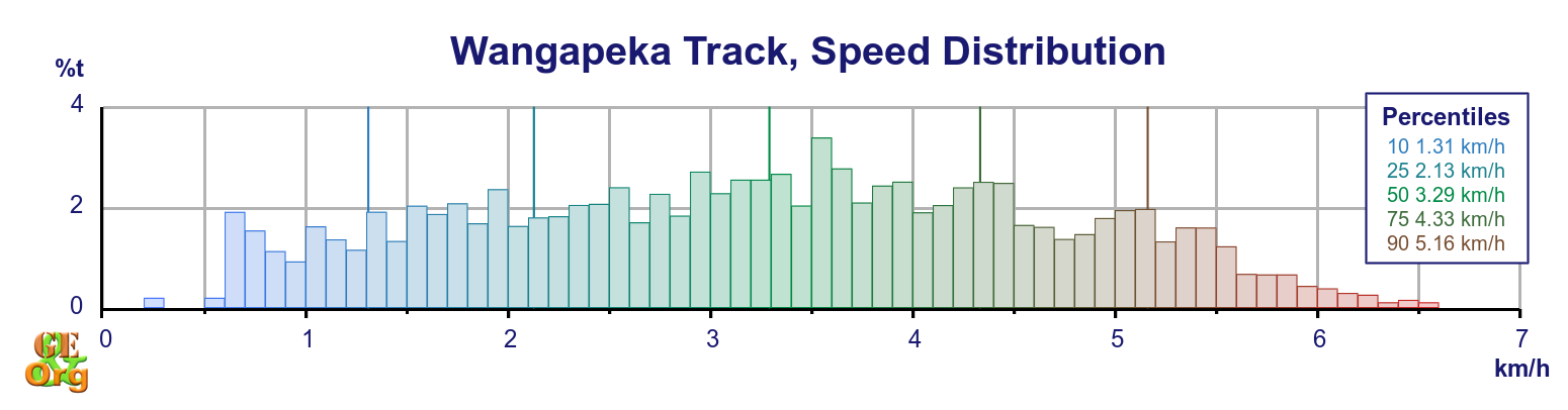
| Totals | 58.7 km | 18:02 h | 2:07 h | 3.25 km/h | 3.29|3.93 km/h | 3000 m (M) | 2772 m (M) |
| Summary of the Wangapeka Track. Climb categories are: Flat (< 1.9°/3.3%), Easy (> 1.9°/3.3%), Moderate (> 3.8°/6.6%), Demanding (> 7.5°/13%, < 15°/27%) | |||||||
The only thing that was worrying about the track was the fact that it had been reclassified as a “route” from previously being a track. This means that upkeep of the track is downgraded, and any further slips, etc. which might impede progress will no longer be bypassed (as was the case near the Karamea end, where recent windfall has almost obliterated the track, but temporary signs have been erected to allow passage, and shortly before Wangapeka Saddle, where a detour around a major slip was well signed). This has meant that a telephone once present at the Karamea end of the track has been removed, although the telephone at Price’s Clearing was still there. These telephones provide (or provided) a secure means of arranging transport off the track at both ends. For alternative accommodation right at the Karamea end of the track, Atawhai Farmstay is a possibility (and they have a phone there as well).
Read more…