This was one of the more enjoyable options of returning from the Heaphy Track, by as direct a means as possible, and as such is one of the classical combination routes. With accommodation and the supermarket in Karamea, this was also an ideal way of doing a much longer hike than would otherwise be possible.
| Section (with links) | Distance | Track Time | Break | Mean speed | Median time|distance | Ascent | Descent |
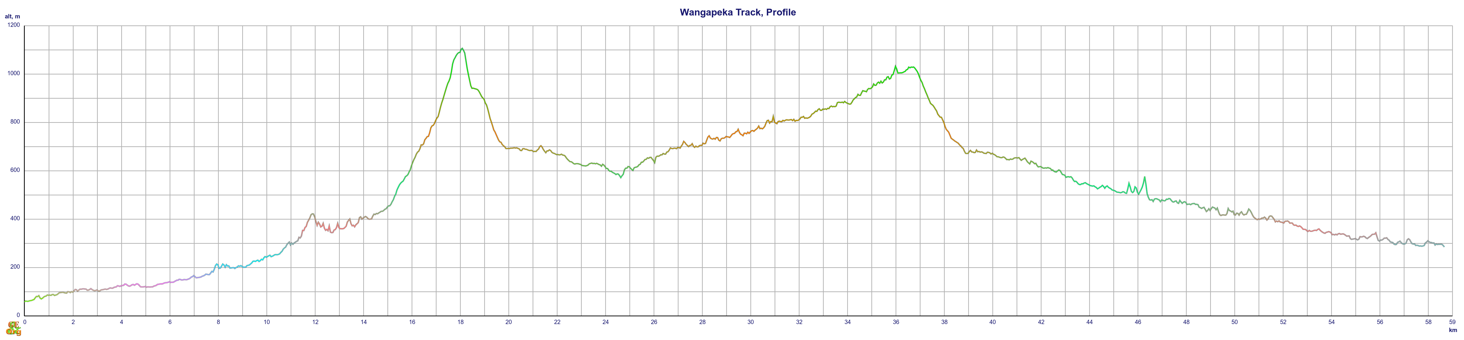
| Little Wanganui Road End – Taipo | 20.3 km | 6:56 h | 0:47 h | 2.93 km/h | 2.74|3.66 km/h | 1475 m (M+) | 835 m (M+) |
| Taipo – Stone | 18.6 km | 6:09 h | 0:40 h | 3.03 km/h | 3.12|3.52 km/h | 889 m (M) | 911 m (M) |
| Stone – Price’s Clearing | 19.7 km | 4:56 h | 0:40 h | 4.00 km/h | 4.21|4.51 km/h | 646 m (M-) | 1033 m (M) |
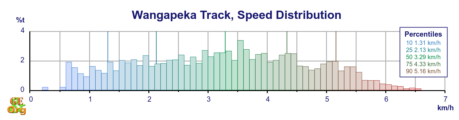
| Totals | 58.7 km | 18:02 h | 2:07 h | 3.25 km/h | 3.29|3.93 km/h | 3000 m (M) | 2772 m (M) |
| Summary of the Wangapeka Track. Climb categories are: Flat (< 1.9°/3.3%), Easy (> 1.9°/3.3%), Moderate (> 3.8°/6.6%), Demanding (> 7.5°/13%, < 15°/27%) | |||||||
The only thing that was worrying about the track was the fact that it had been reclassified as a “route” from previously being a track. This means that upkeep of the track is downgraded, and any further slips, etc. which might impede progress will no longer be bypassed (as was the case near the Karamea end, where recent windfall has almost obliterated the track, but temporary signs have been erected to allow passage, and shortly before Wangapeka Saddle, where a detour around a major slip was well signed). This has meant that a telephone once present at the Karamea end of the track has been removed, although the telephone at Price’s Clearing was still there. These telephones provide (or provided) a secure means of arranging transport off the track at both ends. For alternative accommodation right at the Karamea end of the track, Atawhai Farmstay is a possibility (and they have a phone there as well).
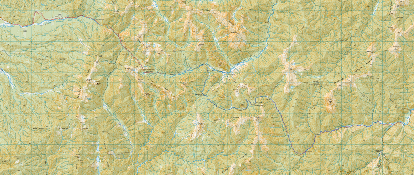
The track itself sticks for the most part to travelling along three rivers: The Little Wanganui, the Taipo and Karamea, and the Wangepeka. The one major alternative route would be to go via Saxon Falls and Trevor Carter Hut down the Karamea River, and then up over the Biggs Tops route which climbs up over 1500 m before heading back down to Wangapeka Saddle. Another completely alternative route would be to take the Leslie-Karamea route, which ends at Cobb’s Reservoir near Upper Takaka. Transport from here is problematical, however.
Other alternatives would be to redistribute the daily hiking load. For the very late start here, reaching Taipo Hut was just possible; staying at Belltown would have relieved the stress considerably. A second day to Trevor Carter would have been quite easy, as would a third day to Stone Hut by either river or mountain routes. The final part of the track is so easy, however, that it is probably not worth trying to stay at either of the King’s Huts.
The condition of the track itself was generally quite good, despite the degradation. The climb up to Little Wanganui Saddle was pretty tough, and the descent on the other side was very steep. Along the upper Karamea River there are high-water and low-water alternatives, and the low water variety involves a bit of wading up the river. From Stone Hut onwards the track improves bit by bit; from King’s Creek Hut until the end the condition is among the best that can be expected from a back country route. However, expect low-lying parts to deteriorate when the weather is bad.
Most of the huts are rather simple affairs, but most have water, firewood and a toilet. King’s Creek Hut (not to be confused with Cecil King’s historical hut a few kilometres down the track) is the most modern of the lot.
Slide Show
The landscape here is dominated by huge landslides, some of which date back to the 1929 Murchison earthquake.
Topo Map with GPS
Technical debriefing. Both the Heaphy and the Wangapeka Tracks were somewhat marred by the loss of two (!) pairs of glasses, and forgetting to pack in the spiderman suit, which is hutwear for the evening, as well as pyjamas.
This may have been survivable (even in worse cases) but it isn’t really necessary. Precautions have to be taken to secure glasses at every step (such as not chopping wood with the glasses in the breast pocket). Packing needs to be double-checked on the morning of departure to ensure that everything is actually in the pack. I think there might have been a bit of overreliance on routine combined with a residue of jetlag. Even if it doesn’t show any redundancy in the system, there’s still no room for complacency.